
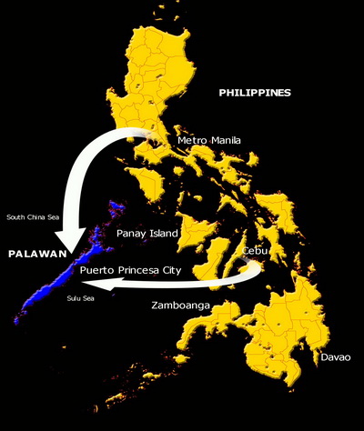
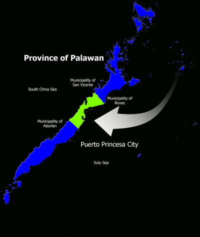
Location and Land Area
The City of Puerto Princesa is located 306 nautical miles southwest of Manila, 205 nautical miles from Panay and about 250 nautical miles from Zamboanga. It is bounded on the North by the Municipality of San Vicente and Roxas and on the South by the Municipality of Aborlan. Its western side faces the South China Sea while in its eastern coast lays the Sulu Sea.
Puerto Princesa City has a total land area of 253,982 hectares making it the largest City in the country.
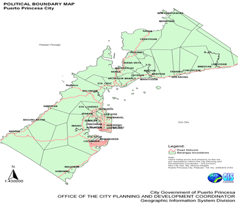
The City is comprised of 35 urban barangays and 31 rural barangays (Table II.1). The total area of the urban barangays is 14,716 hectares or only 5.7941% of the total land area of the City. The largest land area of the City is comprised of the rural barangays with a total area of 239, 266 hectares or 94.2059% of the total land area of the City.
Topography and Slope

More than half (57.43%) of the total land area of Puerto Princesa City have flat to gentle slopes, making the City an ideal site for urban development and agricultural development (Table II.2). Only about 22% of the total land area of the City has severe limitations for settlements and infrastructure development because of steep slopes (>30%). Moderate slopes of 8-18%, which can also be developed for agriculture and low-density housing comprise 15% of the City’s total land area. However, agriculture and settlements development within this moderate slope range has to adopt soil conservation and slope stabilization measures to avoid soil erosion and landslides, respectively.
Seven (7) barangays have more than 80% of their total land area with flat to nearly level land (0-8% slopes). These barangays are highly suitable for agriculture and urban expansion: Bahile, Binduyan, Concepcion, Langogan, Marufinas, San Rafael and Santa Cruz. Remarkably, Bahile has 98% of its total land area with 0-3% slope.
In contrast, 22 barangays have their entire land area comprised of steep slopes (30-50% slopes). These barangays are better left off with substantial forest cover to maintain their ecological stability and prevent accelerated erosion and massive landslides which could affect downstream settlements, agriculture and coastal fisheries. The 22 barangays sitting on critical slopes are: Bagong Pag-asa, Bagong Silang, Kalipay, Liwanag, Mabuhay, Magkakaibigan, Maligaya, Mandaragat, Manggahan, Maningning, Masigla,Masikap, Masipag, Matahimik, Matiyaga, Maunlad, Milagrosa, Model, Pagkakaisa, Princesa, Seaside, Tagumpay and Tanglaw.
The barangays with the largest area of flat lands (0-3%) include Bahile, Bacungan, Langogan, Napsan, Cabayugan, Marufinas, and Binduyan.
Geology

In the southern portion particularly in the Irawan area, metamorphic rocks of the Inagawan Formation can be found. The area is also partly composed of sedimentary Iwahig Formation, alluvium of unconsolidated gravel, sand, pebbles and silt. Some ultramafic rocks of the Palawan Ophiolite Complex also characterize the area.
The northern part of the City is comprised of ultramafic rocks. In particular, the Langogan area is characterized by metamorphic rocks consisting of quartz-feldspathic and mica schists, phyllites, slate and quartzites. The ultramafic rocks consist of unaltered sepertenized pridotite, dunite and pyrexomite.
Babuyan area is made up of Irahuan Metavolcanics which resemble the quartz-hematite schist in appearance and are also friable and weather into dark reddish gray platy fragments which are usually scattered near outcrops of river beds. St. Paul limestone outcrops as small patches are found in the south and midwestern part of the catchment. It is comprised of a very thick, massive, marbleized limestone with very well developed karst.
The Puerto Princesa Subterranean River National Park has karsts limestone formation and is popular tourist destination among local and international tourists. The underground river is about 8.2 kilometers in length and has been proclaimed under Proclamation No. 212 as a National Park. The park covers a protected area of 22,202 hectares. It is also included in the list of World Heritage Sites by UNESCO because of its diverse ecosystem and the presence of rare flora and fauna. The site, which is located in Sabang, barangay Cabayugan has also fine white beaches.
Climate

Rainfall
The City has two prevailing type of climate. The type that prevails in the west coast has two distinct seasons: six months dry (November-April), and six months wet (May-October) with the heaviest recorded rainfall in September, While the lowest or driest month occurs in February. Western barangays of the City (New Panggangan, Marufinas, Cabayugan, Tagabinit, Buenavista, Bahile, Macarascas, Simpocan, Bagong Bayan, and Napsan) fall within this type. The type prevailing in the east coast has short dry season with varying heavy rainfall months. Dry months have been recorded during the months of January to April. Recorded rainiest month is September.
Temperature
Temperature is one of the three most important factors in climate as far as plant growth is concerned. The other two factors are moisture and light. Temperature influences every chemical and physical process connected with plants such as solubility of minerals; absorption of water, gases, etc.; synthesis; growth and reproduction. In the animal world, atmospheric temperatures have profound effect in the reproductive as well as productive efficiency of livestock, like milk production in dairy farming.
The City has a uniform high temperature. However, there is no marked difference in temperature between areas falling under the first and second type of climate. Generally the warmest months are March, April and May, the coolest are November, December, January, and February.
Humidity
The City has more or less uniform as well as high relative humidity. The range is from 79 to 86 percent with an annual mean of 84 percent. Fluctuations in relative humidity affect the rate of evaporation in such a way that if other factors like moisture content of the soil and its temperature and the temperature of the air were momentarily held constant, a lower relative humidity tends to enhance vaporization, while in an extreme case, atmosphere approaches 100 percent, evaporation may cease and condensation induced.
Wind
The City has two distinct prevailing winds, the northeast (NE) monsoon and the southwest (SW) monsoon. The northeast monsoon generally sets in October and continues until April. The monsoon blows mainly between north and northeast with a tendency towards an easterly direction at the end of the season. It has a velocity ranging from 15 to 25 kilometers per hour at its height and an average of 6 kilometers per hour. Rain clouds during the NE monsoon practically lose all the moisture before reaching the southwest part of the archipelago, thus the City and the province as a whole receive no rainfall towards the end of the northeast monsoon (January-April).
The southwest (SW) monsoon or the summer monsoon follows the NE monsoon after a transition period of variable winds and calms. The SW monsoon prevails from June to October. It blows most steadily during July and August although not as steady as the NE monsoon, reaching a maximum velocity of about 35 kilometers per hour. In October or during the close of the SW monsoon, strong winds occur in the southern part of the city. The southwest winds bring torrential rains but with uneven distribution.
The NE and SW monsoons affect the eastern and western part of the City. When these winds blow, the seas are very rough. The calm months of the year are from April through June on both the eastern and western side of the City.
Water Resources

The City has a total of 115,610 hectares of watershed areas of which five watersheds have major river basins and six have medium-sized river basins.
The five river basins with the largest area include Babuyan River (25% of the total catchment area)Montible River (20%), Langogan River (14%), Inagawan River (12%) and Bacungan River (10%). Irawan watershed, which is the main source of water supply in the City, has a small catchment area comprising only 3% of the total catchment area.
Development of groundwater in the City proper to supply part of its water requirements has limited potential because of low yield and partly salt-water intrusion into the fresh water aquifers. However, groundwater abstraction has a better potential in Sta. Monica, Irawan and Iwahig.
The groundwater quality of the City is relatively poor with a pH higher than 7.2, which is the benchmark for good quality groundwater. The groundwater also has high content level of calcium and magnesium making it hard and produces crust deposits when used in boilers.
Soil types
Lowland soils found in the City are mostly alluvial in formation and are usually fertile soils; hence they are classified as prime agricultural lands. This type of soil formation is suitable for irrigation and has potential for good yields of rice. Upland soils are usually formed in place from underlying bedrocks. They are usually thin compared to alluvial deposits and are also prone to erosion in the absence of vegetation cover.
In terms of soil types, there are nine kinds found distributed in City: Bolinao Clay, Tagburos Clay, Tapul Clay Loam, Guimbalaon Clay, Bay Clay Loam, Babuyan Silt Clay Loam, Babuyan Clay, Malaglag Clay, and Hydrosol.
Land Classification

Based on the data of the National Mapping and Resource Information Authority (NAMRIA), Alienable and Disposable (A & D) lands were estimated to comprise about 15% of the total land area of the City. Forestland or timberland, which cannot be titled, covers almost 11% of the total area of Puerto Princesa. The unclassified public forestland makes up 74% of the total land area of the City. This implies that many of the residents who are occupying lands in the City do not have titles.
It is uncommon to find that A&D lands totaling to 4,643 hectares or 14% of the total A&D lands are located in slopes above 18% thereby making these lands susceptible to erosion and eventually land degradation when they are developed into agriculture or settlements. 26 barangays in the City have A&D lands above 18% in slope The barangays with the largest A&D lands located in slopes above 18% are Buenavista (38% of the total A&D lands above 18% in slope), Lucbuan (11%) and Maruyugon (8%).
Land and Sea Cover
Based on the data generated by the Mapping Team of the ECAN Zoning Project using 2005 SPOT5 satellite imageries, about 73% of the total land area Puerto Princesa is still forested with primary forest (7%), secondary forest (52%), limestone forest (1%), and ultramafic forest (13%). Its remaining mangrove forest covers a total area of 5,737 hectares. Brushlands and grasslands, which can be developed into forest plantations, orchards, upland agriculture and even settlements, comprise 14% of the total land area of the city.
Lands cultivated to agriculture are substantial covering a total area of 19,549 hectares or about 10% of the total land area of the City.
Built-up areas were measured to be about 3,993 hectares or 1.85% of the City’ total land area from the 2,376 hectares under the Land Use Survey conducted in 1999. This means that the built-up areas have increased by 1,617 hectares or 68% in five years posting an average annual increase of about 323 hectares.
The SPOT5 satellite imageries used were able to identify for mapping the coastal habitats in the coastal waters of Puerto Princesa. Although the deeper portions of the coastal water was not covered, mapping of the shallower portions produced the following measurements: coral reefs cover 3,074 hectares, dense seagrass with 836 hectares and sparse seagrass with 880 hectares.
The Land/Sea Cover map of Puerto Princesa City. It depicts the spatial distribution of the different types of vegetation cover, land uses and coastal habitats’ cover.
Terrestrial Flora

The forest cover of PPC was measured in 1992 under the JAFTA project and was recorded to have 149,317 hectares. In 1998, another measurement of the City’s forest cover revealed that it slightly increased to 151,405 hectares. The increase was attributed to the reforestation undertaken by the City and other organizations such as the PCSDS, DENR, NGOs and POs. In the measurement done by the ECAN Zoning Project in 2005 using SPOT5 imageries, the total forest cover (primary, secondary, limestone and ultramafic forests) of the City was recorded at 159,203 hectares posting an increase of 7,798 hectares from 1998.
A survey was conducted by the Flora Survey Team of the ECAN Zoning Project in 2005 covering selected watersheds in the City. The watersheds selected are those that serve as catchments to the major rivers in the City; present and potential sources of water supply; and critical to sustaining the productivity of the agriculture in the lowland and coastal/marine habitats and fisheries.
The watersheds covered in the survey include:
Northern Puerto Princesa City
- Langogan
- Maoyon
- Tagabinet
- Sabang
- Bahile
- Talaudyong
- Nagtabon Forest
Southern Puerto Princesa City
- Napsan Traverse
- Montible Brushland
- Central Peak
- Mt. Salakot
- Mt. Beaufort
- Irawan Downslope
Terrestrial Fauna

The Fauna survey team conducted its reconnaissance survey in seven barangays, namely: Mt. Salakot, Barangay Napsan, Barangay Simpocan, Barangay Nagtabon, Barangay Langogan, Barangay Bahile, Barangay Irawan, and Barangay Iwahig. Several sampling sites were selected in each 7 barangays where transects were established. The selected sampling sites are more or less the same with the sampling sites of the Flora team for consistency purposes.
The Fauna team was able to identify a total of 135 species in 63 families and 19 orders. The 11 amphibians are distributed in 4 families and 1 order, and the 7 reptiles in 6 families in 1 order and 2 sub-orders. Ninety-four species of birds are distributed in 40 families and 10 orders while the 23 mammals in 13 families and 7 orders. The top 4 barangays which registered the highest species count are: Langogan (67), Bahile (67), Napsan (64), and Irawan (61).
Mammal species diversity and richness, have the following highest ranked areas: Napsan (H’ =0.467, R = 3.74), Simpokan (H’ = 0.402, R = 3.33), Langogan (H’ = 0.259, R = 1.31) and Bahile (H’ = 0.178, R =1.52). The relative ranks for bird species diversity and richness show Bahile ( H’ = 1.57, R = 3.61) having the highest value followed by Irawan (H’ = 1.51, R = 3.78), Langogan (H’ =1.49, R = 3.59), Napsan (H’ = 1.44, R = 3.30) and Bacungan (H’ =1.42, R = 3.60). Reptile diversity and richness are all low, but the ranking of the highest are as follows: Bacungan (H’-0.439, R- 0.83), Bahile and Irawan, having both H’ = 0.30, R = 1.41, Langogan and Simpokan with H’ = 0.217, R = 1.512). Amphibian species diversity and richness show Simpokan (H’ = 0.5008, R =0.84), Bahile (H’ = 0.4000, R = 1.15), Irawan (H’ =0.468, R = 0.657), Bacungan (H’= 0.346, R = 0.530) as the top barangays.
In terms of overall species richness, the following barangays: Bahile, Simpokan, Napsan and Langogan. Species diversity in all sampling sites was relatively low with less than 2.5 index value.
Puerto Princesa has 33% of the total count of Palawan endemics. Amphibians have the highest endemicity at 45% (5 species); birds registered 34% (32 species) and mammals posted 35% (8 species). The level of endemism by barangay is as follows starting from the highest: Napsan – 47% (30 species); Irawan – 43% (26 species); Langogan – 35% (24 species); Simpukan -38% (18 species); Montible – 38% (13 species); and Bahile – 29% (20 species).
About 45% of the number of threatened species in Palawan (i.e., 38 species) is found in Puerto Princesa (i.e., 17 species). Of the total number of threatened species in Puerto Princesa City, mammals registered the highest with 30% or 7 species, followed by reptiles with 14% or one species, birds with 9% or 8 species, and amphibians with 9% or one species. Table II.10 shows the ranking of barangays in terms of the number of threatened species.
The Flagship species are those which are locally endemic and/or threatened, and/or rare in the Philippines and found only in Palawan. In Puerto Princesa the flagship species consist of 10 mammal species, 47 birds, 1 reptile and 5 amphibians. Overall, Napsan has the greatest number of flagship species (42) followed by Irawan (34), Bahile (29), Simpukan (28), Iwahig (22), Nagtabon (17), and Langogan (13). This presence of flagship species is also an important factor for determining the importance of a site as a core zone or a buffer zone.
Mangroves
The Mangrove survey team of the ECAN Zoning Project conducted its survey of the mangrove areas in the coastal areas of Puerto Princesa from March 28 to May 10, 2005. The survey laid out 195 in different locations selected as sampling sites. The survey recorded 18 true and 20 associate mangrove species belonging to 14 families and 27 genera of vascular plants.
Mangrove species which were found to be widely distributed include: Rhizophora apiculata (Ra), Rhizophora mucronata (Rm), Ceriops tagal (Ct),Xylocarpus granatum (Xg), Bruguiera gymnorrhiza (Bg), Sonneratia alba(Sa),Rhizophora stylosa (Rs),Heritiera littoralis (Hl) ,Bruguiera cylindrica (Bc), and Ceriops decandra.
The most dominant and important species recorded is Rhizophora apiculata (Ra). It is also the most frequent and dense mangrove species recorded. The other species most frequently encountered and with characteristically dense cover are Bruguiera gymnorhiza (Bg), Ceriops tagal (Ct), Sonneratia alba (Sa), Rhizophora mucronata (Rm), Xylocarpus granatum (Xg), Rhizophora stylosa (Rs), Sonneratia caseolaris (Sc), Bruguiera cylindrica (Bc).
In terms of species diversity, the top five (5) most diverse sampling sites are Macarascas (2 sampling sites), Sicsican, Kamuning, and Dos Palmas. Almost all sampling sites in Puerto Princesa City ranges from very low-to-low relative values of biodiversity indices using the Shannon index of measure. Likewise, the evenness of distribution of species abundances was low in all transects.
Based on the results of the survey, the mangrove forest conditions in Puerto Princesa can be aptly summarized as follows:
- Most of the sampling sites in Puerto Princesa City have an open/logged-over stocking mostly in pole sizes; only Bahile has adequate stocking and six sampling sites have moderate stocking: transects Bagong Silang, Macarascas; Manalo River, Manalo; Bacungan River, Sta. Cruz; San Jose Plantation, San Jose; Naglaom, Mangingisda; and Puntod River, Kamuning.
- Mangrove forests in the City have generally low volume forest stand; only 17 transects (9%) out of 125 transects have moderate to high volume stands;
- Intact mangrove forest with old growth stands were recorded in the following sampling sites:
- Honda bay: boundary of Salvacion (near boundary of Manalo, Tapol River, Siñaran), Sta. Cruz (Kalatubog river), Bacungan River and San Jose.
- Ulugan bay: barangays Bahile and Macarascas.
- Puerto Princesa bay: Lulubog – lilitaw island, Barangay Sicsican, Tawiran and Zigsag, Luzviminda
There are mangrove plantation in Concepcion, Tanabag, Dos Palmas, Snake Island, Starfish Island, Manalo, Sta. Lourdes, Bacungan and San Jose. The Plantation in barangay Manalo had robust growth, taller and high survival rate.
Based on the 1986 aerial photographs of NAMRIA, mangrove forest cover was estimated to be about 5,917 hectares. The ECAN Zoning Project, using 2004 SPOT5 imageries, measured the area of remaining mangrove cover in Puerto Princesa City to be 5,737 hectares. The decrease of 180 hectares over a period of 18 years or about 10 hectares per year is attributed to the rampant cutting of trees for fuel wood, charcoal making and housing materials. Clearing of mangroves for fishpond development substantially contributed to the receding forest cover. The decrease in mangrove cover over the same period could have been bigger if not for the efforts of the DENR, LGU, NGOs and POs to reforest denuded areas. About 1,344 hectares of mangroves were rehabilitated during the period 1900-1995 with a survival rate of 55% as reported by the DENR.
Marine Mammals and Sea Turtles
The Marine Survey Team of the ECAN Zoning Project adopted an interview survey technique in its study of marine mammals and sea turtles in Puerto Princesa. A total of three hundred eight (308) key informant interviews with fishers were conducted on April 2005 in 28 coastal barangays surrounding Puerto Princesa Bay, Ulugan Bay and the West Coast, and Honda Bay. The interviews were supplemented by a two-day opportunistic boat survey to verify the presence of species reported in the interview. The difficulty of actually seeing the presence of Dugong, sea turtles, dolphins and whales in the coastal waters of Puerto Princesa given the limited time and resources of the project resorted to the employment of the survey interview technique.
Dugong
Dugong individuals were sighted by the respondents to be feeding the coastal waters of Langogan, San Rafael, and Babuyan in Honda Bay; Bancao-bancao, Mangingisda, and Kamuning in Puerto Bay; Napsan in the West Coast; and Tagabinet in Ulugan Bay. Animal sightings often occurred in November in Ulugan bay and the west coast and from November to April in Puerto Princesa bay and Honda bay. Dugongs were usually seen during the early mornings before 10:00 o’clock. They were commonly spotted singly but sometimes in groups of three to five particularly in Honda and Puerto Princesa bays.
Turtles
Turtle species common to Puerto Princesa are the Hawksbill turtle, Green turtle, and the Olive Ridley. Based on the respondents’ account and aided by photographs, the commonly sighted turtle species in the areas surveyed was the hawksbill turtle (Eretmochelys imbricata) imbricata) particularly in Barangays Mangingisda and Bancao-Bancao in Puerto Bay; and, Bagong Bayan and New Panggangan in the west coast.
The green turtle (Chelonia mydas) was frequently seen in Nagtabon and Langogan, while the olive ridley (Lepidochelys olivacea) was reported to occur in Salvacion and Tagabinet.
The turtles were seen to be mating, eating seaweeds, and resting in reef crevices in Puerto Princesa Bay and Ulugan Bay. Turtles are seen everyday at anytime of the day. They are usually spotted during the month of April, November and December when they come to the beach areas to nest.
The nesting sites of sea turtles were reported to be located Marufinas, Nagtabon, Kamuning, and Rita Island. Female turtles, possibly hawksbill and green turtles, usually come to shore to nest during the months of April, November, and December.
During the month of November, turtles were reported to nest in Kamuning in Puerto Bay; in December, they were observed to nest in Snake Island in Honda Bay; Napsan, Simpocan, and Nagtabon in the West Coast; and, New Panggangan in the Ulugan Bay area; and in April, they nest in the West Coast and Ulugan Bay area particularly in Nagtabon and Marufinas.
Cetaceans
Two types of dolphins are usually sighted in the coastal waters of Puerto Princesa. The bottlenose dolphins were observed swimming in the shallow waters of Babuyan’s marine sanctuary while the spinner dolphins were sighted by the Marine Survey Team of the ECAN Zoning Project in the coastal waters of Binduyan, just 500 meters from the shoreline.
Dolphin sightings were highest during April as reported by the respondents. The respondents also reported that Dolphins were sighted everyday at anytime particularly in Honda Bay and offshore Puerto Princesa Bay. In Honda Bay, dolphins were observed to feed on squid. In the West Coast, dolphins were commonly sighted in the early mornings, before ten o’clock. They are usually seen feeding on shrimps.
Sightings of whales were rare and limited in all the areas surveyed. When seen, they are usually found in the deeper parts of the sea and were usually seen in the early mornings before ten o’clock. Whales were observed to be logging, feeding on shrimps, swimming, and surfacing for air when they sighted by the respondents.
Whale blows reaching 2-4 meters high were seen by the respondents in Puerto Princesa Bay, particularly in the offshore waters of Mangingisda and Pagkakaisa. The respondents reported the same experience from Napsan in the West Coast, and in San Rafael in Honda Bay. Highest sighting occurrences for whales in offshore Puerto Princesa Bay, and the West Coast respectively were in April and November.
Puerto Princesa is a potential destination for dolphin watching because of the regularity of their appearance in the east coast particularly Honda bay. Similarly, whale watching can be a potential tourist attraction in the offshore waters of the east coast adjacent to Puerto Princesa and Honda bays. Figure II.8 shows the locations where whales were sighted.
Presidential Proclamation 2152
Presidential Proclamation 215 declares that all mangrove areas in Puerto Princesa are part of the Mangrove Swamp Forest Reserves and prohibits, effective in 1981, any conversion of mangrove into other land uses such as fishpond. However, before the effectivity of this law, there were already 723.6 hectares of mangrove in Puerto Princesa covered with Fishpond Lease Agreement (FLA) which are located in Honda Bay (272.6 has), Ulugan Bay (301 has) and Puerto Princesa Bay (150 has).
In June 2000, the DENR-CENRO reported that 185 hectares of mangrove forests were converted into fishponds and beach resorts.
The Survey Team reported that mangrove in Sta. Lourdes (123.85 has.), Tagburos (272.80 has.), Bacungan (378.96 has.) and Kamuning (886.15 has.) commonly known as STAGBAK are covered with CBFMA issued in 2001 under the ADB-JBIC funded project. About 900 hectares of mudflats/tidal-flats were also afforested with Rhizophora spp (R. stylosa, R. apiculata, and R. mucronata) from 1996 to 1998 under the Fisheries Sector Project funded by ADB which are located in Ulugan Bay (200 has), Honda Bay (400 has) and Puerto Princesa Bay (300 has). Currently, there are at least five (5) areas of mangroves developed and promoted as part of ecological tourist destination namely: Bahile, Sabang, Bat Island, Bakau Island, San Jose and Dos Palmas.